

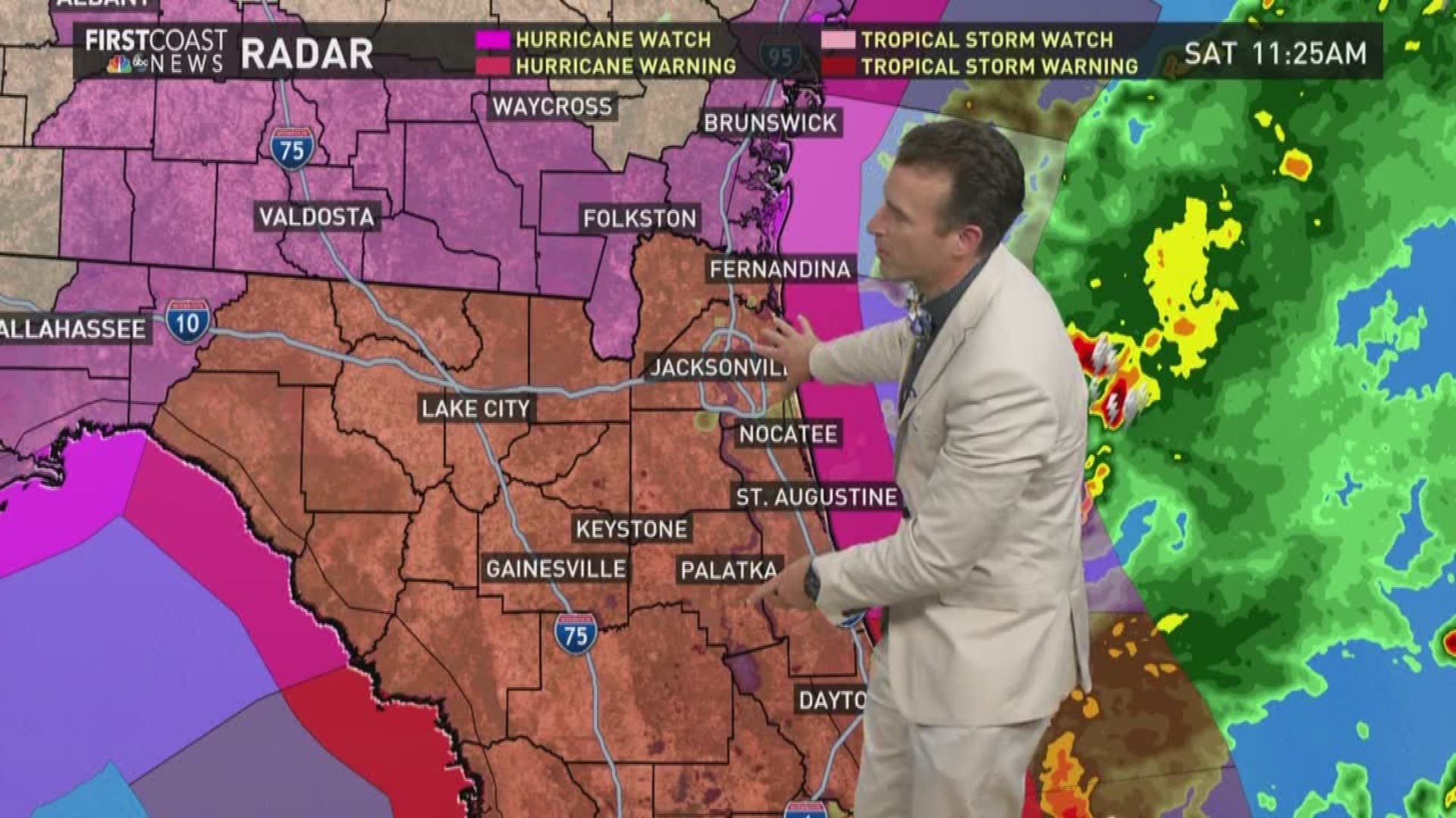
A hurricane warning has been issued for areas in the First Coast.
Governor Rick Scott declared a state of emergency for all 67 Florida counties ahead of Irma.
"Hurricane Irma is a major and life-threatening storm and Florida must be prepared," Scott said.
5:30 p.m. Sept 10: Naval Station Mayport's entrance at the base will be closing to all traffic 6 p.m.
5:00 p.m. Sept 10: President Trump approves Governor Scott's major disaster declaration meaning federal funds will pay for 30 days of disaster relief for the state of Florida.
3:45 p.m. Sept 10: A reminder to anyone evacuating with pets that if you have a pet who passes away while you're evacuating, sad as it is, the Jacksonville Pet Funeral home located at 4969 Beach Boulevard is open and willing to help. They have had three calls today already.
2:56 p.m. Sept. 10: Flagler County has issued an emergency order extending the curfew from 7 a.m. Monday morning to noon. The ban on the sale of alcohol continues and includes bars and restaurants in addition to liquor stores and grocery stores.
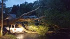
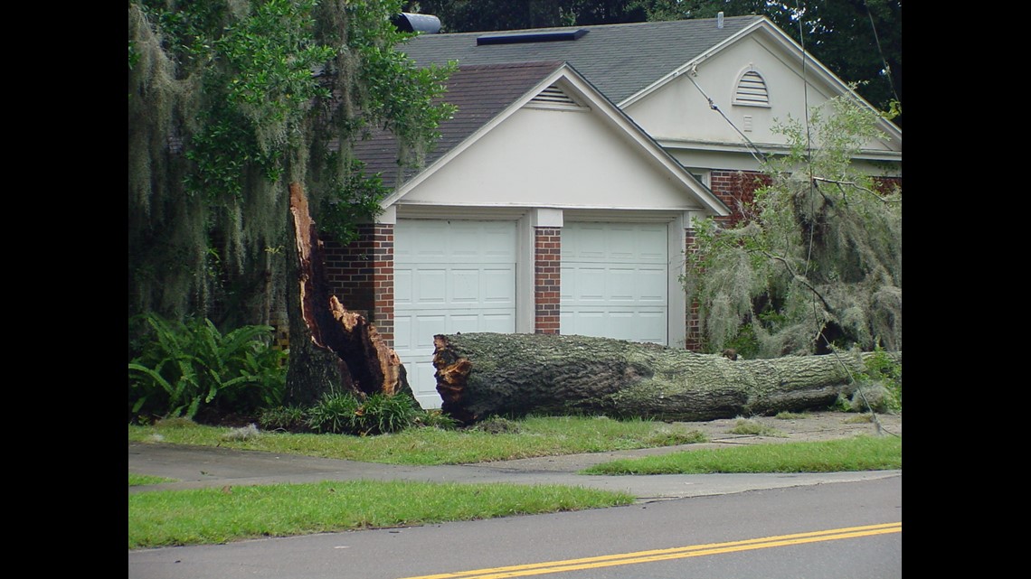
2:33 p.m. Sept. 10: Tree fell over at Lane and Hyde Grove. Water Oak toppled from wind and rain - no injury, property damaged.

- @kangel6, FCN Reporter
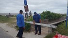
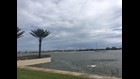
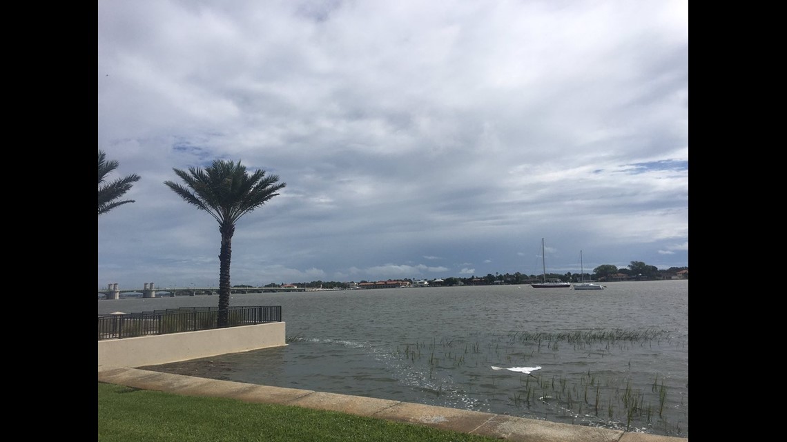
2:08 p.m. Sept. 10: The Bridge of Lions in St. Augustine has been closed due to flooding.
2:01 p.m. Sept. 10: The Tornado Warning for Flagler County has expired.
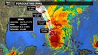
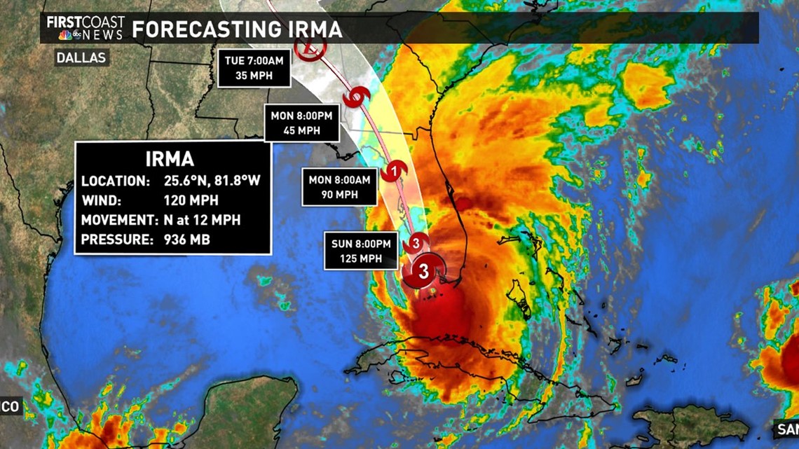
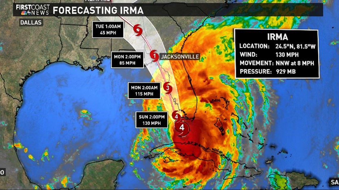
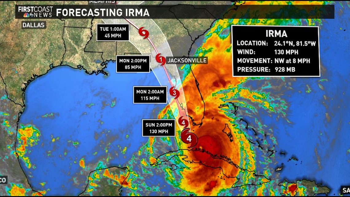
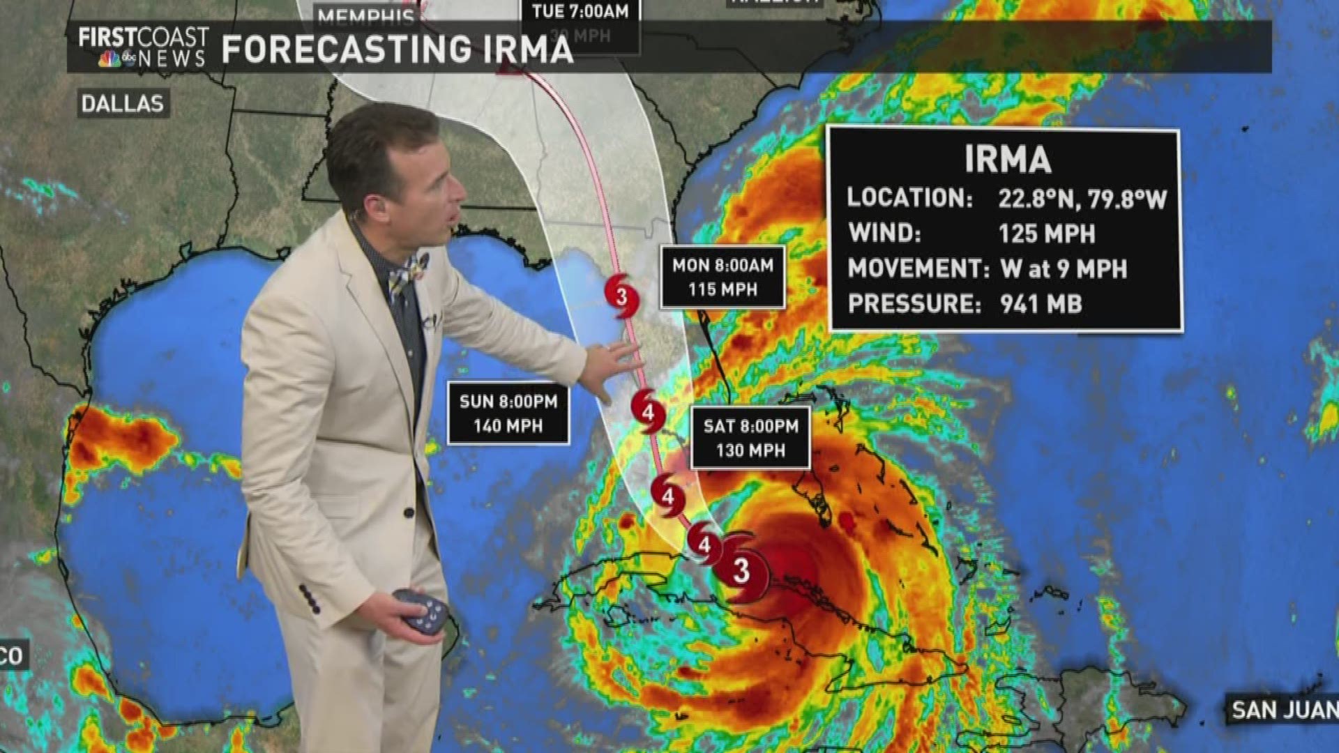
2 p.m. Sept. 10: Hurricane Irma has been downgraded to a Category 3 storm with maximum sustained winds of 120 mph. Strongest winds expected in Marco Island and Naples area within the next couple of hours. The storm has picked up movement, tracking due north at 12 mph.
1:58 p.m. Sept. 10: Nassau County has issued a curfew, to include pedestrian and vehicular movement, beginning tonight at 6 p.m. through 8 a.m. daily until cancelled or terminated.
1:56 p.m. Sept. 10: U.S. Senators Marco Rubio, R-FL, and Bill Nelson, D-FL, urged President Trump to grant Florida Governor Rick Scott's request for a federal disaster declaration in response to Hurricane Irma.
1:49 p.m. Sept. 10: Jacksonville mayor says their manual gauges recorded 35 mph sustained winds, so they are standing by. EOC will announce if/when they reach 40 mph.
- @NewsShelby, FCN Reporter
1:46 p.m. Sept. 10: The bay has settled down. The tide is starting to go out, but the roads are still waist deep in some parts.
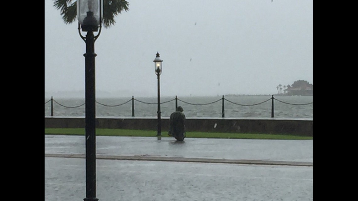
- @tvjoe12, FCN Photographer
1:35 p.m. Sept. 10: Deacon Scott Conway, superintendent of Catholic Schools for the Diocese of St. Augustine, has decided to keep all Catholic schools closed on Tuesday, Sept. 12, due to the Hurricane Irma.
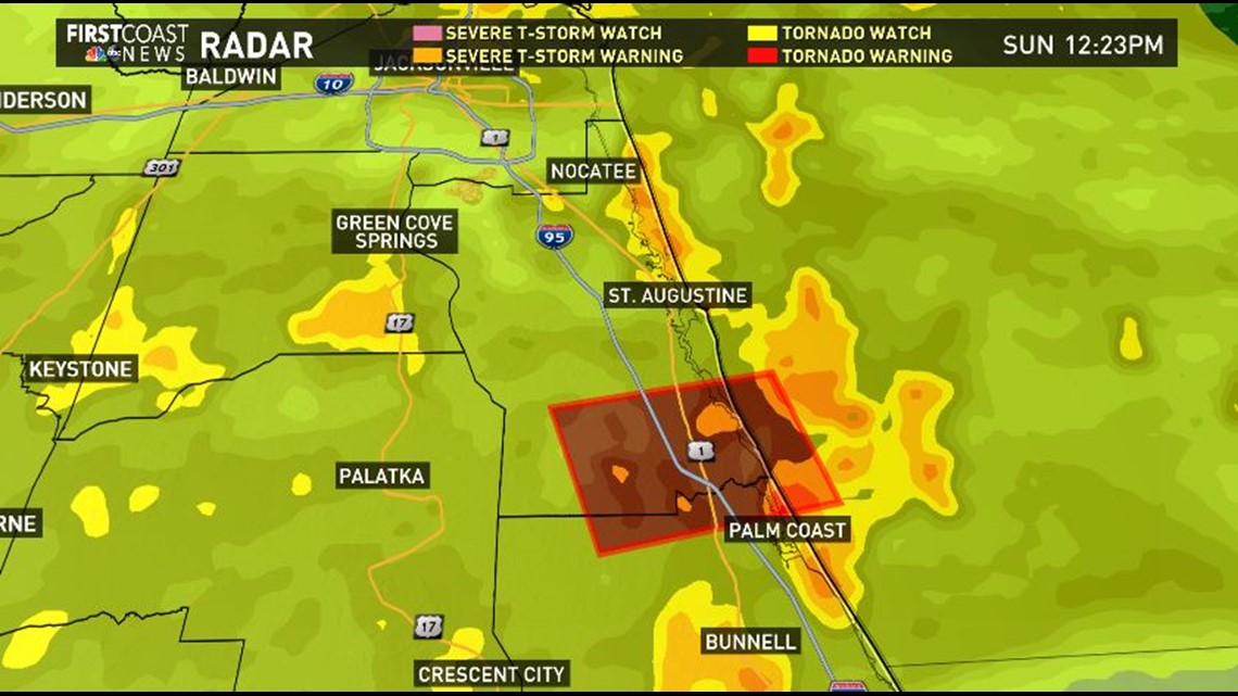
1:32 p.m. Sept. 10: A Tornado Warning has been issued for Flagler County.
12:53 p.m. Sept. 10: National Hurricane Center update shows slight eastward adjustment and slightly faster weakening so our forecast does not change. Worst will be over in Northeast Florida 3 p.m. Monday.
- @fcntim, FCN Meteorologist
12:44 p.m. Sept. 10: Tornado Warning for St. Johns, Flager has been cancelled. Tornado Watch remains in place.
- @_WeatherStove, FCN Meteorologist
12:42 p.m. Sept. 10: An Osprey just caught a fish in the middle of San Marco ave in St Augustine.

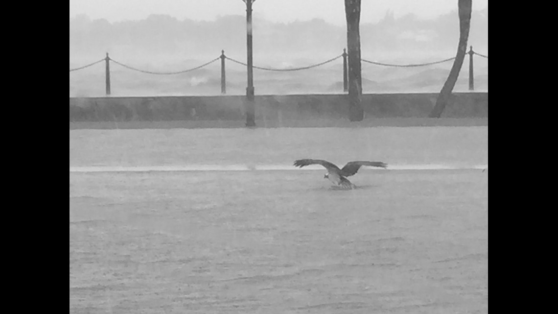
- @tvjoe12, FCN Photographer
12:26 p.m. Sept. 10: Tornado Warning issued for Flagler County and St. Johns County. Warning expires at 1 p.m.
12:11 p.m. Sept. 10: Glynn County is urging people who remain in the county to shelter in place beginning at noon Sunday.
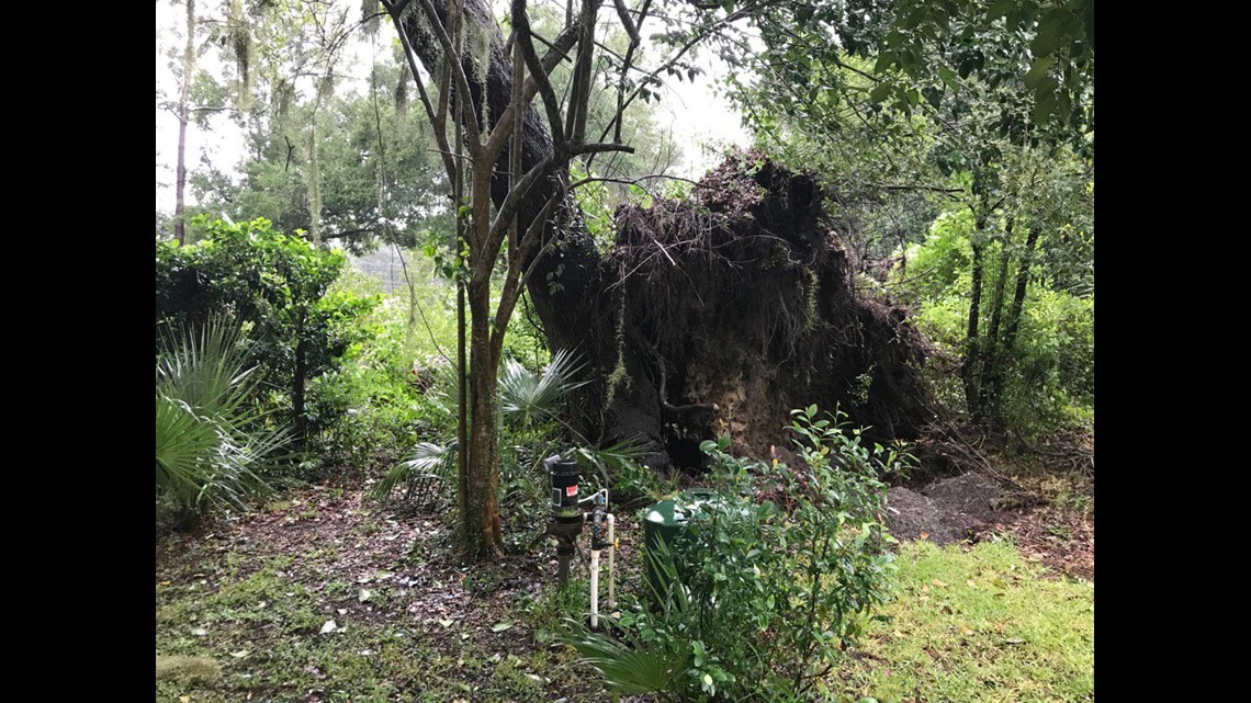
Early Sunday morning, a large tree fell into the driveway of a residence on Stewart Avenue in St. Simons Island, crushing two cars. Both people and two dogs inside the home are safe.
Public Works crews on scene told First Coast News it was one of two trees to fall on St. Simons Island and an additional tree fell on the mainland.
Water and sewer services will be shut off on St. Simons Island at 2 p.m. Sunday. Service will be restored once the storm passes and permanent power is re-established.
- @JulietteDryer, FCN Reporter
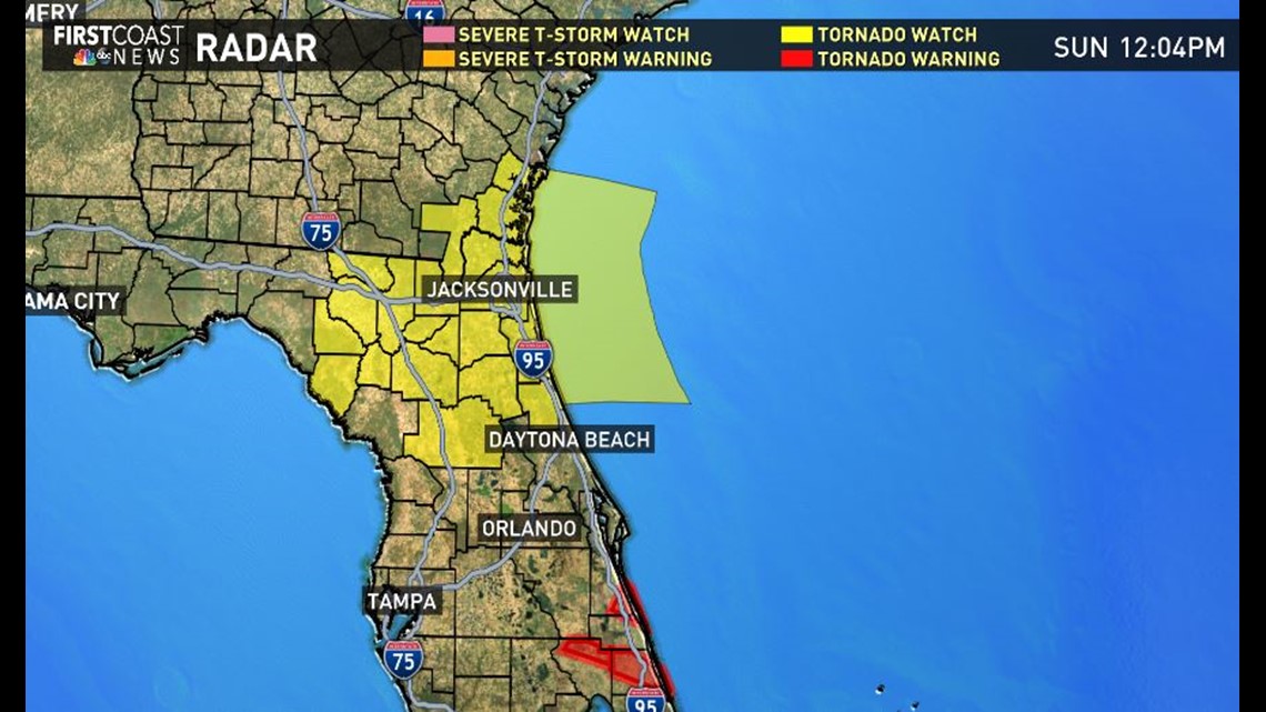
12:04 p.m. Sept. 10: A tornado watch has been issued until midnight for portions of our area.
- @fcnmike, FCN Meteorologist
12 p.m. Sept. 10: The Sidney Lainer Bridge in Glynn County, Ga. has been closed.
12 p.m. Sept. 10: Many schools on the First Coast are deciding to extend school cancellations through Tuesday, Sept. 12, due to Hurricane Irma.
11: 50 a.m. Sept. 10: A large tree has fallen, taking down power lines in Fairfax area of Jacksonville. Police have rerouted traffic.

11:38 a.m. Sept. 10: Bradford County has enforced a countywide curfew beginning Sunday, Sept. 10 at 12 p.m. and ending on Monday, Sept. 11 at 8 p.m. Only emergency vehicles, utility vehicles and personnel working to restore services affected by the storm should be on the roads of the city during these hours.
11:27 a.m. Sept. 10: Tropical Storm Warnings have been issued for Brantley, Charlton and Ware Counties in Georgia.
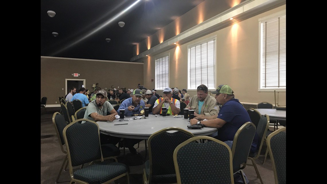
11:19 a.m. Sept. 10: JEA trucks are prepared for the aftermath.

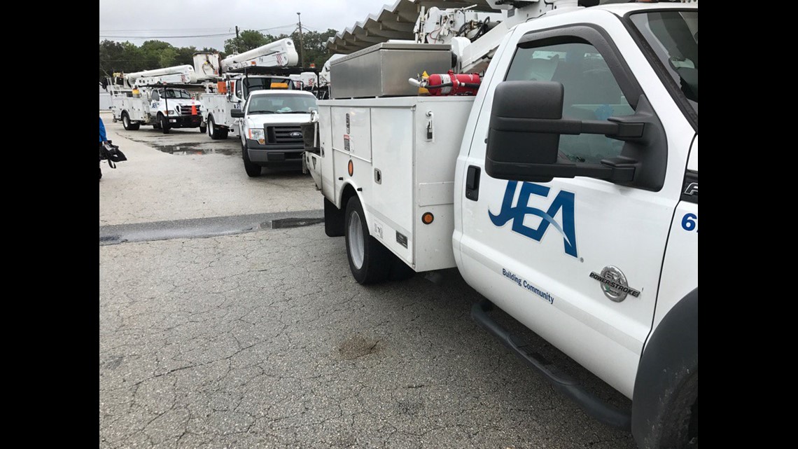
- @kangel6, FCN Reporter
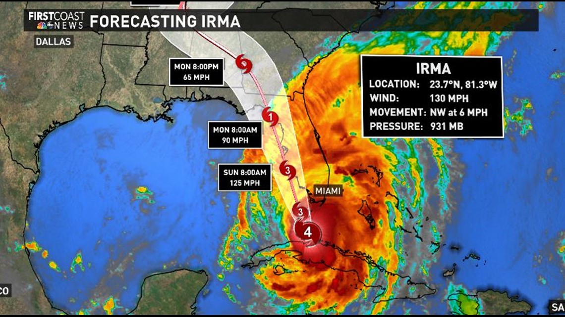
11 a.m. Sept. 10: Hurricane Irma remains a Category 4 storm, headed towards the Southwest Florida coast. Winds continue to increase over South Florida as the storm moves due north at 9 mph. Irma is approximately 80 miles south-southeast of Naples and about 115 miles south-southeast of Ft. Myers.
10:54 a.m. Sept. 10: The first has fallen. Wind gusts no more than 25 mph and a tree has broken, collapsing a power line in Starke. Still 24 hrs from highest winds.
- @Dan_Grossman, 9NEWS Reporter
10:47 a.m. Sept. 10: IRMA ADDED: Sports Corner in St. Augustine is boarded-up, but made a list of hurricanes they've experienced.


- @AlexOsiadacz, FCN Reporter
10:45 a.m. Sept. 10: The Bolles School and Riverside Presbyterian Day School have extended class cancellations through Tuesday, Sept. 12.
10:39 a.m. Sept. 10: Lake Asbury Jr. High School in Clay County is at capacity as a special needs shelter. Thrasher-Horne will open at 1 p.m. today as an additional special needs shelter.
10:24 a.m. Sept. 10: Duval County public schools will remain closed on Tuesday, Sept. 12.
10:21 a.m. Sept. 10: Jacksonville Sheriff's Office announces that bridges at the beaches will be closed at the same time once sustained wind speeds reach 40 mph
10:15 a.m. Sept. 10: St. Johns County schools will remain closed on Tuesday, Sept. 12, due to Hurricane Irma.
10:11 a.m. Sept. 10: Clay County School District announces that schools and district offices will remain closed on Tuesday, Sept. 12, due to Hurricane Irma.
9:34 a.m. Sept. 10: The City of St. Augustine water system is experiencing low water pressure as a result of a service pump not operating. The problems is being addressed and is unrelated to Hurricane Irma.
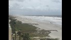
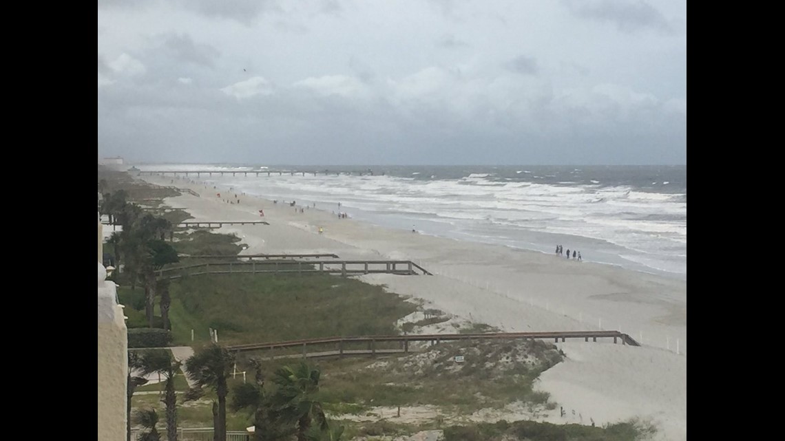
9:20 a.m. Sept. 10: Current wind speed in Jacksonville Beach at 35 mph with gusts to 48 almost to tropical storm force. Surf of 12 ft. + late day.
- @fcnmike, FCN Meteorologist
8:54 a.m. Sept. 10: St. Johns County EOC announces that Fire Rescue is gearing up for an anticipated increase in 911 calls once winds and rains associated with Hurricane Irma reach St. Johns County. The Communications Center will have extra staff on hand to coordinate response to variety of public safety emergencies expected during and after the storm.
8:21 a.m. Sept. 10: ABC News reports that there are now three confirmed weather-related deaths in Florida due to Hurricane Irma. All of which have been car accidents.
8:15 a.m. Sept. 10: National Weather Service reporting 2.6 inches of rain in Starke already today. Twenty-six miles SW in Gainesville, 36 inches have fallen since June. Soggy ground + wind = not good.
- @Dan_Grossman, 9NEWS Reporter
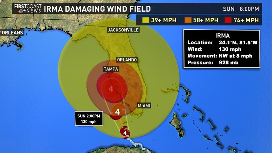
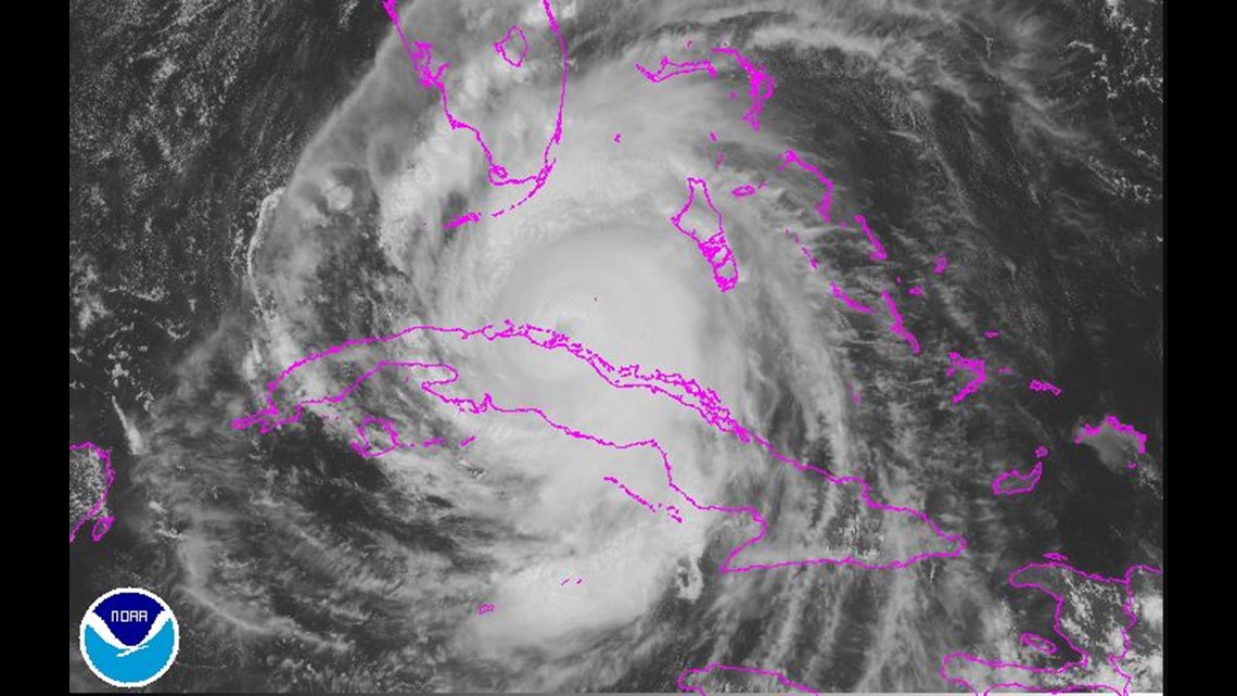
8 a.m. Sept. 10: The center of Hurricane Irma is about to make landfall in the lower Florida Keys. Irma remains a Category 4 storm with maximum sustained winds of 130 mph. Irma is now tracking north-northwestward at 8 mph and is approximately 20 miles east-southeast of Key West and close to 100 miles south of Naples.
7:43 a.m. Sept. 10: ABC News reports one confirmed weather-related death caused by Hurricane Irma. Brings death toll to 23, including those from the Caribbean.
6:46 a.m. Sept. 10: Northern eye wall of Irma beginning to move over FL Keys. Extreme Wind Warning issued for gusts of 115 mph possible through 9 a.m.
- @WeatherLauren, FCN Meteorologist
6:36 a.m. Sept. 10: TREE DOWN: Stewart Ave in SSI. Thankfully Jane and Dean are safe. This could be a sign of things to come.


- @JulietteDryer, FCN Reporter
6:25 a.m. Sept. 10: Flood Warning issued for portions of Baker, Clay, Duval, St. Johns. Have already seen three inches of rain; two to three inches more are expected by noon.
- @WeatherLauren, FCN Meteorologist
5:52 a.m. Sept. 10: Jacksonville PD are standing by at the Hart Bridge ready to close off traffic if maximum sustained winds reach 45 mph for 1 min.

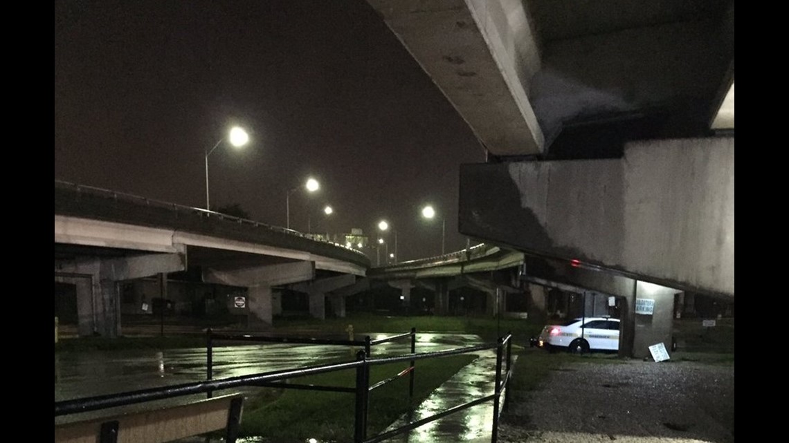
- @RobNesbittNews, WCSH Reporter
5:47 a.m. Sept. 10: This is why we're urging folks in Jacksonville to not focus on the cone. Winds extend well away from the core of Irma.
- @WeatherLauren, FCN Meteorologist
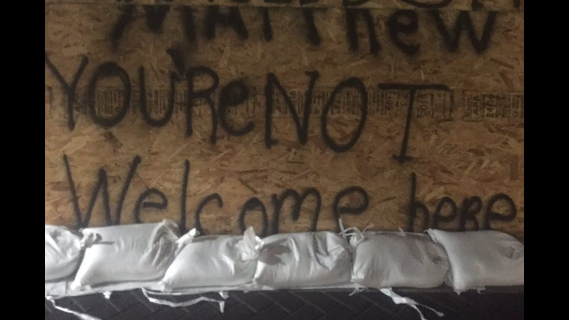
5:32 a.m. Sept. 10: 1st St. of Jax Beach is boarded up, some with messages written, ready for Hurricane Irma.

- @Katie_Jeffries, FCN Reporter
5:02 a.m. Sept. 10: 5 a.m. NHC Irma update: Hurricane has strengthened a bit, but shear keeps it from intensifying much more. Track shifts slightly west.
- @WeatherLauren, FCN Meteorologist
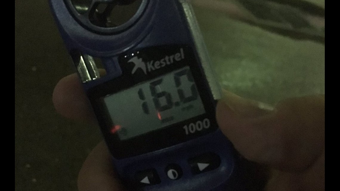
4 a.m. Sept. 10: Current wind speed here at the Hart Bridge on ramp is maxing out at 16mph.

- John Blunda, WCSH Video Journalist
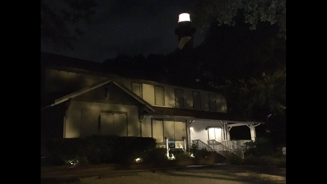
3:43 a.m. Sept. 10: No rain right now near St. Augustine lighthouse, but the wind is picking-up.

- @AlexOsiadacz, FCN Reporter
3:20 a.m. Sept. 10: ST SIMONS: We're in this together! Water and sewer service will be shut off at 2 p.m. today.


- @JulietteDryer, FCN Reporter
2:31 a.m. Sept. 10: Irma is back to Cat 4 status approaching the FL Keys; complete NHC update at 5 a.m.
- @WeatherLauren, FCN Meteorologist
9 p.m. Sept. 9: Florida A&M University is closed through Friday, Sept. 15.
8:50 p.m. Sept. 9: The Coast Guard has set port condition Zulu, with ports in Jacksonville and Fernandina closing in preparation for Irma.
8:25 p.m. Sept. 9: The Baker County Sheriff's Office is ordering mandatory evacuations for the following areas, many of which are near the St. Marys River:
- All residents on Steel Bridge Road, east of the collection site
- All residents on Webb Haven Road
- Persimmon and Ash Road in the Turkey Creek II neighborhood
- Myrtle, Camphor, Chestnut, and Gum Roads
- All residents on the west side of Aspen Road
- All residents on Lil Dixie Trail
- All residents on River Oak Circle
- All residents on River Oak Drive
- All residents on Confederate Drive East
- All residents of Cedar Creek Farms Road
6:30 p.m. Sept. 9: The City of Starke will have a travel curfew from 8 p.m. Sunday, Sept. 10, to 8 p.m. Monday, Sept. 11. Only emergency vehicles will be allowed to travel through this area during that 24-hour period.
6:20 p.m. Sept. 9: There will be a mandatory curfew for Jacksonville beaches between 10 p.m. and 6 a.m. tonight and tomorrow morning.
6:15 p.m. Sept. 9: Florida State University will be closed through Friday, Sept. 15, due to the storm.
6:07 p.m. Sept. 9: Greyhound is canceling its services Saturday and Sunday, but will be open Monday as of Saturday.
4:15 p.m. Sept. 9: Water and sewer service to shut down on St Simons Island at 2 p.m. Sunday
3:36 p.m. Sept. 9: AT&T plans to ignore overage charges for Florida customers during Hurricane Irma.
The service provider will waive overage charges from Thursday, September 8 to Sunday, September 17.
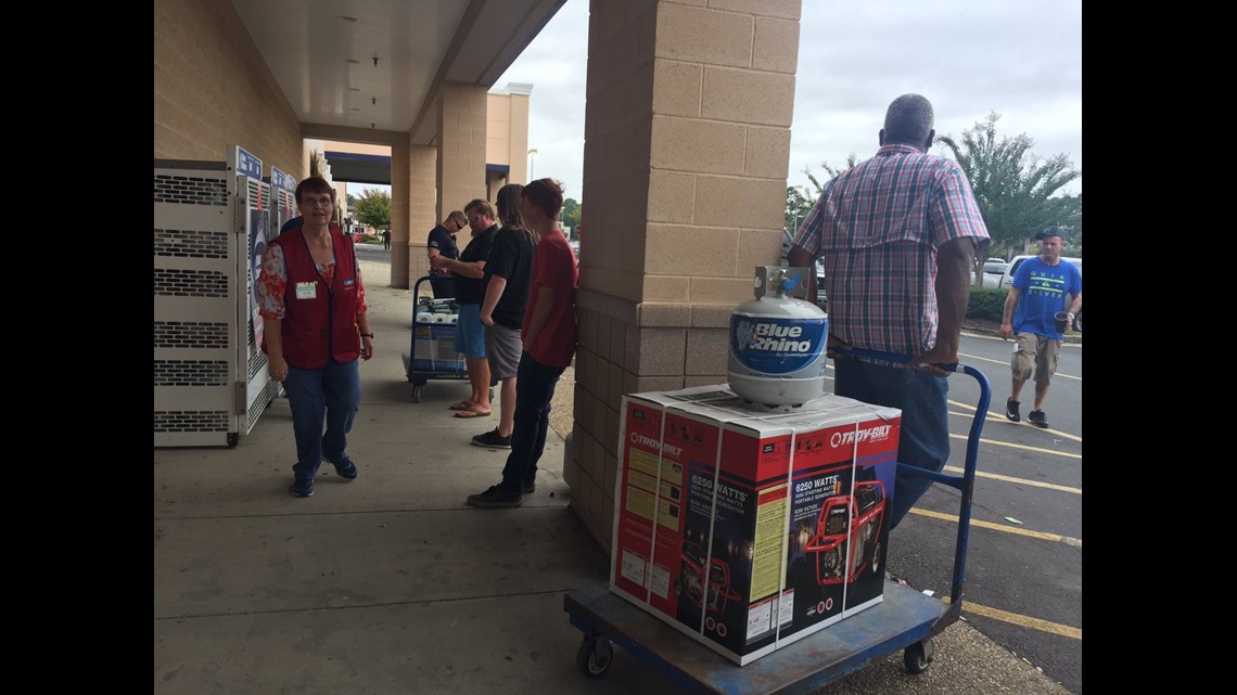
3 p.m. Sept. 9: Hagan Ace Hardware at 12501 San Jose Blvd. just received a shipment of propane. The store is open until 8 p.m.
2:54 p.m. Sept. 9: St. Johns County EOC announces that electric and water services will be maintained for as long as possible.
"There is no plans to curtail water and sewer service for a majority of the county. Water and sewer service to the barrier islands will remain operable until the integrity of the system is threatened or it is determined unsafe to allow staff to remain on the Islands."
2:45 p.m. Sept. 9: Mayor Lenny Curry spoke on Irma's impacts on the First Coast. He said during the height of the storm, despite local 911 centers being double-stagged, that call capacities might be met. If you have a non-medical emergency call 904-630-CITY.
2:16 p.m. Sept. 9: St. Johns County EOC announces that after 4 p.m. on Saturday, the drawbridges at the Bridge of Lions and SR 206 bridge will no longer open for marine vessels.
2 p.m. Sept. 9: Hurricane Irma remains a Category 3 storm with maximum sustained winds at 125 mph. The storm is approximately 145 miles southeast of Key West, tracking due west at 9 mph.
A Hurricane Warning is in effect for Fernandina Beach southward around the Florida peninsula to the Aucilla River, Florida Keys, Lake Okeechobee and Florida Bay.
A Hurricane Watch is in effect for north of Fernandina Beach to Edisto Beach and West of the Aucilla River to Indian Pass.

1:55 p.m. Sept. 9: Traffic on I-95 N very light near Baymeadows in Jax, a day before Irma's strongest impact window begins.
- @JeffValin, FCN Reporter
1:51 p.m. Sept. 9: Duke Energy issues a statement about rumors that the power company is de-energizing services due to Hurricane Irma evacuations.
"Duke Energy is not de-energizing services in any area to expedite evacuations. On occasion, we may de-energize services at the request of emergency management officials. Please remember to adhere to your state and local emergency management for updates and information regarding evacuations."
1:43 p.m. Sept. 9: Though the beaches technically closed at 10 a.m., that is an order that doesn't seem to be followed. Several people are still at the beach taking pictures or walking dogs.
No one seems to be entering the water though. With the choppy waves, entering the water would be dangerous.
The double red flags are flying, meaning the water is closed for swimming.
- @Katie_Jeffries, FCN Reporter
1:28 p.m. Sept. 9: The St. Johns County Ocean and Fishing Pier and all related facilities, including the parking lot, have been closed in anticipation of Hurricane Irma.
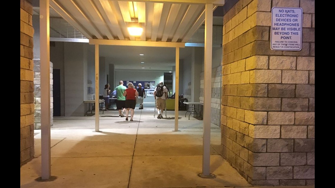
1:02 p.m. Sept. 9: The Legends Center on Jacksonville's Northside has reached capacity. There are 11 hurricane shelters still available in Duval County.
12:55 p.m. Sept. 9: Pedro Menendez High School hurricane shelter in St. Johns County is nearing capacity. Evacuees without special needs or pets are encouraged to seek shelter at the remaining general population shelters.
12:24 p.m. Sept. 9: Glynn County public works crews closing off beach access at Goulds Inlet.

- @JulietteDryer, FCN Reporter
11:58 a.m. Sept. 9: Mayor's safety briefing with first responders soon to start.

- @kangel6, FCN Reporter
11:44 a.m. Sept. 9: Windy along the Matanzas Inlet in St. Augustine. We're watching the last minute preparations in downtown.
- @AlexOsiadacz, FCN Reporter
11:33 a.m. Sept. 9: A tropical storm watch has been declared for all areas of Glynn County. A nor'easter may affect the area as soon as Sunday morning bringing along 40-60 mph winds, heavy rains and coastal flooding.
11:30 a.m. Sept. 9: Still plenty of generators, water but no gas cans at the only Lowes in Glynn County, Ga.

- @mgarcianews, FCN Reporter
11:22 a.m. Sept. 9: Hurricane Warnings issued for the following Florida counties: Baker, Bradford, Clay, Nassau, Putnam and Union.
Hurricane Watches are now in effect for Glynn and Camden Counties in Georgia.
11 a.m. Sept. 9: Hurricane Irma has been downgraded to a Category 3 hurricane with maximum sustained winds of 125 mph. The storm is approximately 175 miles southeast of Key West, tracking due west at 9 mph.
The Hurricane Warning for the east coast of the United States has been extended northward to Fernandina Beach and the Hurricane Watch has been extended from north of Fernandina Beach to Edisto Beach.
The government of Cuba has extended the Hurricane Warning to the Havana province. The government of the Bahamas has adjusted the Hurricane Warning to only include Andros Island, Bimini and Grand Bahama.
10:18 a.m. Sept. 9: Naval Station Mayport has moved to "Mission Essential Personnel Only" ahead of Hurricane Irma. Starting at noon Saturday, only RED mission essential cardholders and BLUE housing resident cardholders will be allowed access to the base.
10:17 a.m. Sept. 9: If you live in Brunswick, Ga. and you want supplies, you are out of luck.
Home Depot closed yesterday at 7 p.m. Employees tell me it was a corporate decision because they're under mandatory evacuation. Walmart also closed. Ace Hardware, the only other tool supply store, is located on St Simons Island likely closed. It's not confirmed yet.
Liquor store and Publix are open!
Dozens of cars in parking lot at Publix. Village at Glynn Place Shopping Center store closes at 2 p.m.


- @mgarcianews, FCN Reporter
10:06 a.m. Sept. 9: Flagler County has issued a curfew for Zone A that will go into effect at 7 p.m. Saturday, Sept. 9. Zone A includes everything east of the Intracoastal including Marineland, Hammock and Flagler Beach along A1A. Curfew will be in effect daily from 7 p.m. to 7 a.m. until further notice.
9:20 a.m. Sept. 9: Beach access will be closed in Atlantic, Neptune and Jacksonville starting at 10 a.m. Saturday, Sept 9, according to Jacksonville Beach Ocean Rescue.
9:09 a.m. Sept. 9: The National Weather Service has issued a Flash Flood Watch and Hurricane Watch for all of Duval County. The Flash Flood Watch is effective through 8 p.m. Monday, Sept. 11.
"Citizens should expect heavy rain and increased wind conditions over the next 48 hours through Monday evening."
8:07 a.m. Sept. 9: Already more than a 200 people have checked-in to the shelter at Pedro Menendez as of 8 a.m. Saturday.
Evacuees bringing what they can fit into their cars, some just in plastic bags. We were waiting in line with evacuees who were here before 5 o'clock.
St. Johns County issues mandatory evacuations for Zones A and B including the City of St. Augustine and Town of Hastings. That went into effect at 6 this morning, which is the same time shelters opened.
The issue we've seen at this general facility is some people were trying to bring pets.
Pedro Menendez High School is not a pet friendly shelter, but there is one a few miles down the road at Southwoods Elementary. Another pet friendly shelter is at Timberlin Creek Elementary.

- @AlexOsiadacz, FCN Reporter
8:06 a.m. Sept. 9: Many people on St. Simons Island have heeded evacuation orders and left the island.
The evacuation order for all of Glynn County went into effect Friday morning.
During the period of the mandatory evacuations, travel within the county will not be restricted until tropical storm force winds arrive. The public will be notified in advance of any road closures.
Additionally, a curfew will be in effect for the duration of a state of emergency. The curfew is from midnight to 6 a.m. until Tuesday, Sept. 12.
Glynn County Parks and the St. Simons Island Pier are closed until further notice.
No shelters will open in Glynn County or other Georgia coastal communities.
- @JulietteDryer, FCN Reporter
8 a.m. Sept. 9: Hurricane Irma is hitting hard the north coast of Cuba. The terrain of Cuba has weakened the hurricane but restrengthening is anticipated.
Irma remains a Category 4 storm, but maximum sustained wind speeds have dropped to 130 mph. The storm is about 225 miles south of Miami and is tracking west at 12 mph.
Hurricane Warnings for Central Bahamas and the Ragged Island have been discontinued.

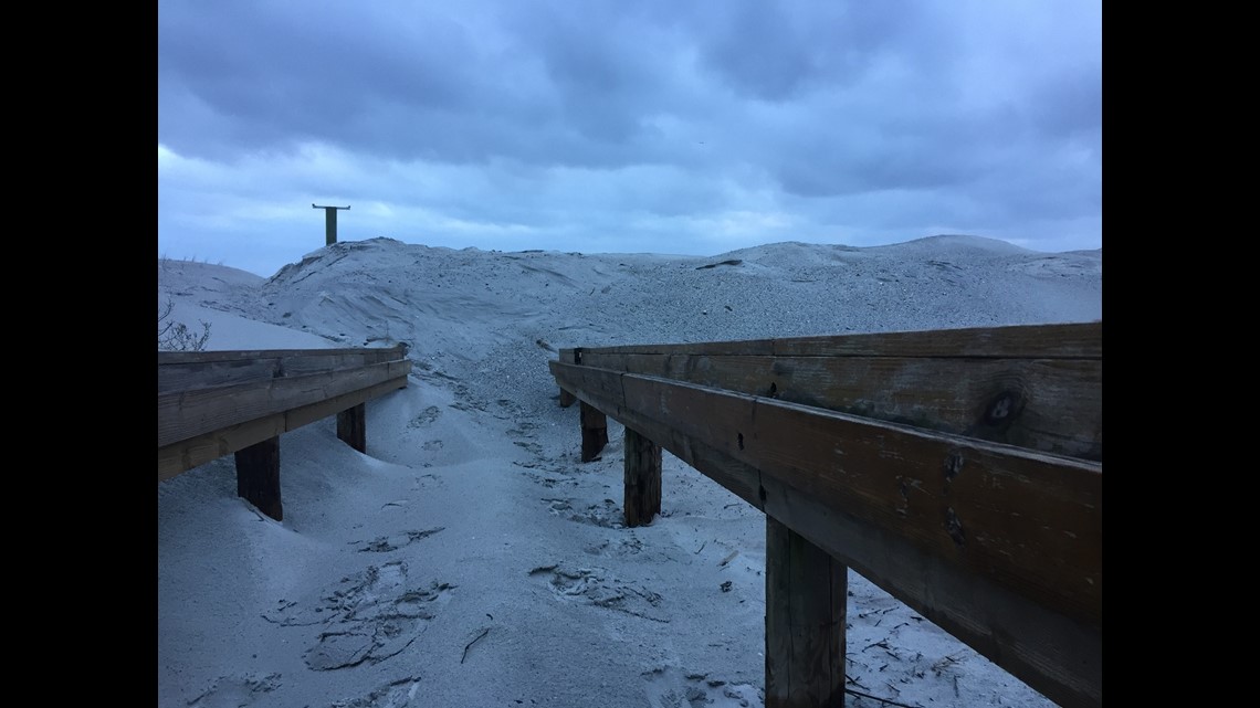
7:47 a.m. Sept. 9: On top of the dune remediation in the aftermath of Matthew, Jacksonville Beach officials have taken an extra step of precaution as well.
They say they noticed a great deal of flooding from Matthew's storm surge occurred at the breakaway areas around beach access points.
That's why the town used bulldozers to move in 8-foot tall barriers of sand at these access points, including the area by the Lifeguard station.
Residents will notice various beach accesses blocked by 8-foot piles of sand, all in an effort to prevent any flooding as Irma passes to our west.

- @LewTurner, FCN Anchor,
5:11 a.m. Sept. 9: A Hurricane Warning is extended northward along the Florida East coast to the Flagler/Volusia County Line.
11:37 p.m. Sept. 8: A Hurricane Watch is in effect for all of Northeast Florida inland to Fernandina Beach. This means wind gusts of 39 mph or higher can be expected by late Sunday night. Hurricane force wind gusts of 74 mph or higher are possible by Monday morning.