
TEMPLE, Texas — STAY WEATHER AWARE: Download the KCEN 6 News mobile app for iPhone and Android to stay up-to-date with any severe weather, including coverage during Tornado Warnings.
Other helpful weather tools:
- LIVE RADAR: An interactive map that shows you live weather conditions.
- HOUR-BY-HOUR: Check out your forecast throughout the day.
- 10-DAY FORECAST: Check out the expected weather conditions in the days to come.
-----
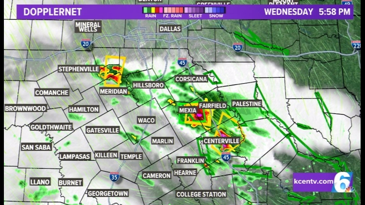
6:45PM UPDATE - Several storms across Central Texas turned severe this evening, with the main storm over Limestone County dropping BUCKETS of rain, in addition to 60+ mph winds and Quarter Sized hail near Mexia. Another storm developed in Bosque County before sliding out of Central Texas, and another storm developed in Leon County around 6:30, capable of quarter-sized hail and damaging winds.
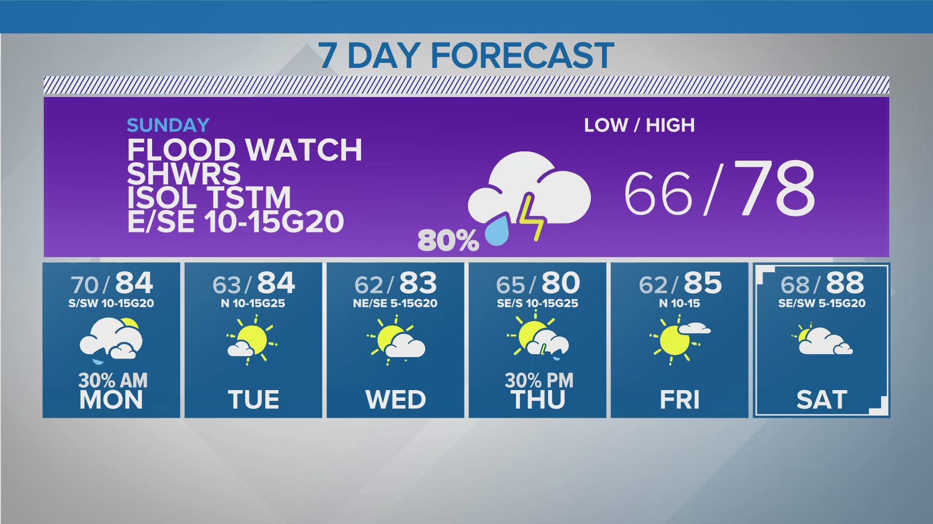
The whole area remains under a SLIGHT risk for Severe Weather into the overnight hours, as well as a FLOOD WATCH through tomorrow afternoon.
TODAY/TONIGHT: Storms were already developing across Central Texas as early as 3pm this afternoon. Most storms were light in nature, though a couple of cells did bring some moderate rain and lightning to a few areas. As we head through this evening, expect the intensity to increase. Some severe weather is possible for Wednesday evening, but the BEST chances for strong to severe thunderstorms move in overnight. A line of thunderstorms is possible between 1am and daybreak across the area. The best chance for severe weather will be before about 3am. All modes will be possible with this: hail, damaging wind and an isolated tornado threat. Some rain may linger into the mid-morning hours Thursday. A FLOOD WATCH is in effect through Thursday afternoon for all of Central Texas, due to the already saturated soils and 2+" we could see through tomorrow.
LOW: 68
WIND: SE 5-10 mph
TOMORROW: Storms should come to an end by noon, but we cannot rule out more isolated to scattered thunderstorms for tomorrow afternoon. Some could, again, be strong in nature, with mainly a hail and wind threat. Another WIDESPREAD chance for strong to severe storms comes in OVERNIGHT (again), once again bringing a chance for damaging winds and large hail. This will be along a cold front that will stall out just around the area by Friday morning. With the clouds and rain, expect temperatures to top out in the lower 80's tomorrow afternoon.
HIGH: 81
WIND: SE 5-10 mph
EXTENDED FORECAST:
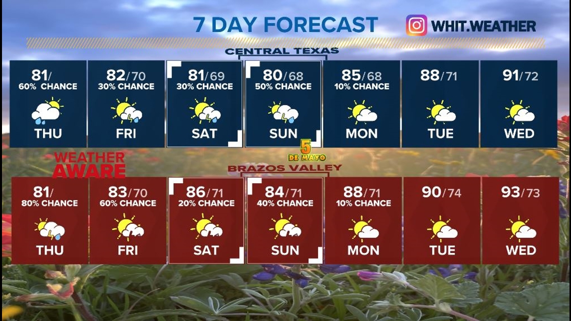
TODAY: 60% RAIN WITH ADDITIONAL SHOWERS FORMING. A STRONG THUNDERSTORM POSSIBLE THIS EVENING ESPECIALLY FAR WESTERN COUNTIES. HIGH 81 AND OTHERWISE MOSTLY CLOUDY SKIES.
TONIGHT: MOSTLY CLOUDY WITH NUMEROUS SHOWERS POSSIBLE. LOW 70. FLASH FLOODING WILL BE LIKELY ESPECIALLY EAST OF I-35.
TOMORROW: MOSTLY CLOUDY, 30% SHOWERS AND STORMS. ESE WIND 5-10MPH. HIGH 82. FLASH FLOODING THREAT EARLY.
SATURDAY: MOSTLY CLOUDY 30% RAIN, SOUTHEAST WIND 8-12MPH HIGH 81.
SUNDAY: MOSTLY CLOUDY 30% RAIN, SE WIND BREEZY 10-15 MPH. HIGH 80.
MONDAY: PARTLY CLOUDY STRAY SHOWER POSSIBLE, 68/85.
TUESDAY: PARTLY CLOUDY VERY WARM, 71/88. HUMID.
WEDNESDAY: PARTLY CLOUDY VERY WARM AND HUMID, 72/91.