
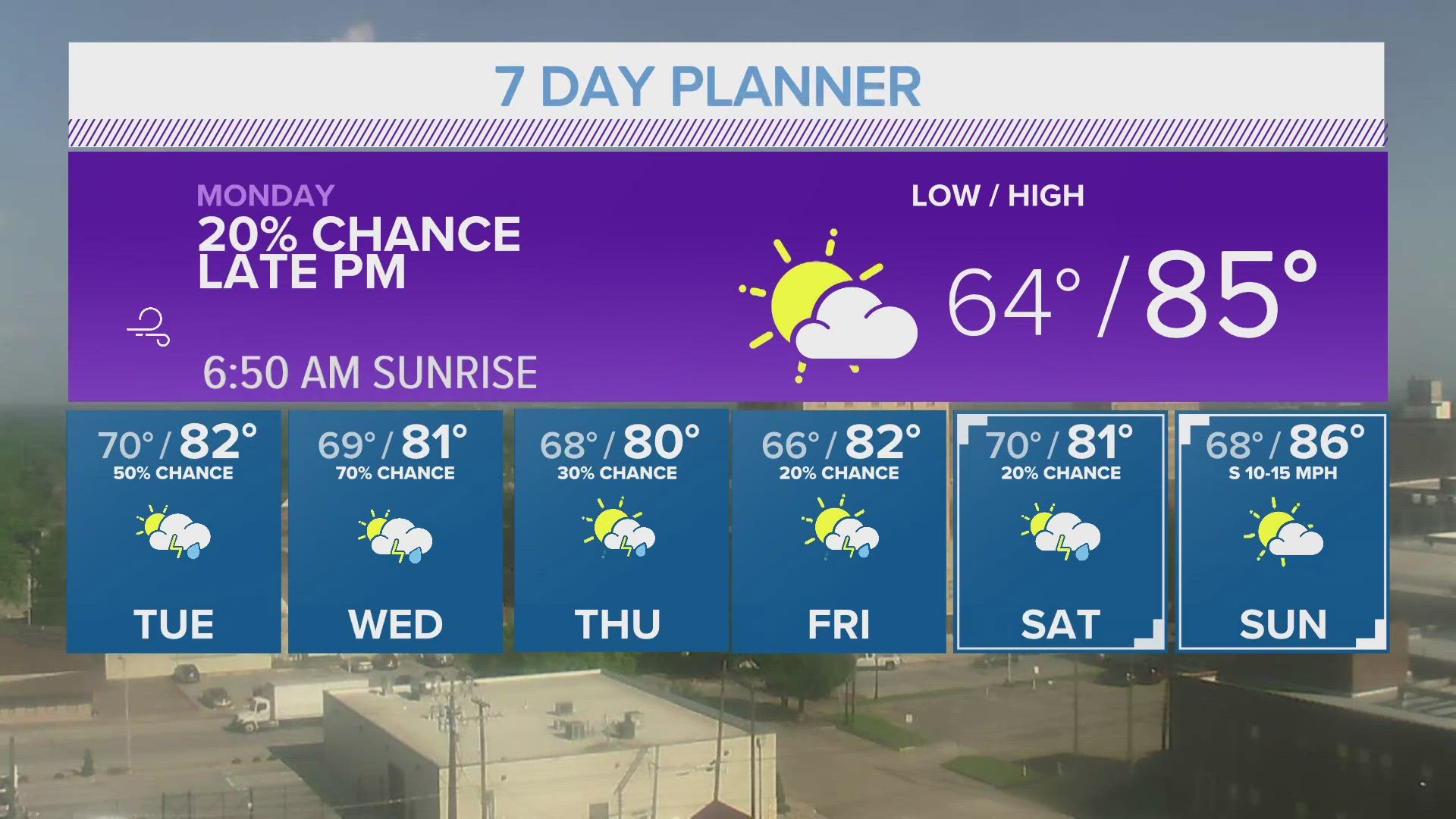
TEMPLE, Texas — TODAY/TONIGHT: A nice break from the rain was experienced by all today. In fact, toward the afternoon, the sun decided to come out for a while. Temperatures soared into the mid- and upper-80's across the area. For tonight, we'll be able to cool into the mid-60's before all is said and done. As we wake up tomorrow, we could see a few more areas of fog, though not to the extent we saw this morning. Winds will stay out of the southeast at 5-10 mph.
LOW: 64°
WIND: SE 5-10 mph
TOMORROW: We will stay rain-free for a second day in a row. We'll also see another warm day with temperatures in the mid-80's by tomorrow afternoon. Overall, we'll run about 3-5 degrees above our normals for this time of the year. More cloud cover can be expected than what we saw this afternoon. Heading into tomorrow night, we're watching our next chance for showers and thunderstorms. Currently, our models are not in agreement on what we can expect for Tuesday night. What we know is that storms will fire along a dryline to our west. The question is whether they will hold together by the time they get to Central Texas. That's what we'll need to keep an eye on tomorrow night. If they hold together, we could see some stronger storms move in from the west. We could, also, see the storms fall apart before they get here and we get nothing across Central Texas. Because of the uncertainty, we're maintaining a 20% chance of showers and thunderstorms. Any storms we see would move in late (after 9 or 10 pm)
HIGH: 85°
WIND: SE 5-10 mph
EXTENDED: Storm chances return in earnest on Wednesday. Rain chances increase to 50% and some storms could be strong Wednesday afternoon. We're currently under a LEVEL 1 (MARGINAL) risk for severe weather. Temperatures will top out in the lower 80's. By Thursday, the storm chance increases to 70% with a continued risk for severe storms. Rain chances continue into Friday morning, when a cold front will slide across the region. That should bring an end to the storm chances for a little while, but rain returns by Friday night and lasts (at least for some) into Saturday and Sunday.
Wednesday: Mostly cloudy with highs near 82°. Winds SE 10-15 mph. 50% chance for showers and thunderstorms.
Thursday: Mostly cloudy with highs near 81°. Winds S 5-10 mph. 70% chance for showers and thunderstorms.
Friday: Partly cloudy with highs near 80°. Winds E 5-10 mph. 30% chance of showers and thunderstorms.
Saturday: Partly cloudy with highs near 82°. Winds SE 10-15 mph. 20% chance of showers and thunderstorms.
Sunday: Mostly cloudy with highs near 81°. Winds SE 10-15 mph. 20% chance of showers and thunderstorms.
Monday: Partly cloudy with highs near 86°. Winds S 10-15 mph.